


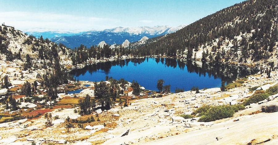

Chamberlain Lake and Infant Buttes are pictured in this photo. The alpine lake is like a postcard with the mountains in the background.
The excitement starts while driving across the San Joaquin River at Jackass Meadow.
To approach the meadow, you have to drive on the cement apron under the San Joaquin River. Water depth can average between 10 and 15 plus inches after the summer months.
Then continue on the dirt and gravel road to Hooper Diversion
Dam. Just before arriving at the dam, look for the old packing trail on the left. This trail will lead you to Hooper or Gordon lake at 9,882 feet.
While unloading my gear at the trailhead, an Edison company employee stopped his vehicle and asked about my destination? I recognized him from our meeting last winter when my snowmobile broke down.
Jim and his wife were on patrol helping out the forest service and came to my rescue. Of course we laughed about our first meeting and he wished me luck on my new adventure.
My first two hours was hiking the switchback trails. At the first major plateau I took a break and this was the first time I previewed the back side of Bear Dome and Infant Buttes.

Tony Krizan
They are hunks of granite that resemble a cone turned upside down. The largest butte is called Bear Dome and the others do not have a name. After three hours of hiking, ahead of me was a grove of trees and it revealed a stream flowing from its interior.
The stream must be from Gordon Lake and this will be the area of my first campsite. I spent the remainder of the afternoon exploring and fishing the lake area. Patches of snow, steep cliffs, pine trees and the still blue water aided my relaxing evening with Mother Nature.
The following morning I’ll hike to Harvey, Hooper and Neil lakes. The ridge to Harvey has a slight increase in elevation to 10,070 feet, followed by Hooper and Neal lakes at an elevation of 10,540 feet.
These lakes have a hybrid trout that have beautiful markings of golden fins with a white underbelly that blend to its main color of greenish brown. I’ll spend another day at Gordon Lake and then tomorrow I’ll proceed on my cross-country adventure to Chamberlain Lake.

Campsite at Chamberlain Lake.
The following morning was brisk at this elevation with no campfire to warm this clear mountain morning. I’ll start by hiking around Neil Lake before attempting this new adventure into an area following around this mountain range.
Some areas in these mountains there are trail markers placed by previous hikers or hunters. I now realize even after looking at my map, no one has ever been hiking in this section of the mountain.
My objective will be to stay at a higher elevation and drop down into Chamberlain Lake. If I follow at a lower elevation, I will be climbing over dead trees, boulder hopping and small stream crossings.
As I maneuvered over this landscaping, I noticed movement ahead moving in my direction. A doe and fawn had just paused at a mountain stream to quench their thirst.
When they noticed me, they scurried off in the opposite direction. After a few hours, below me through the trees I could see the dark blue outline of Chamberlain Lake at 10,459 feet.

Shown is Chamberlain Lake with mountain range in background.
There are steep cliffs that surround three sides of this lake, and pine trees that border the area of water runoff into the valley below. This should be an excellent area for my next campsite.
Now I’ll follow the run-off stream from the glacier at 10,880 feet leading to the lake. From this elevation I could see Florence Lake and visually follow the canyon cut by the San Joaquin River all the way to the Minaret Mountains at the west end of this long valley.
Chamberlain Lake is one of the few Sierra Mountain lakes that are inhabited by large golden trout. I’ve heard stories from previous hikers and now I agree with their statements; 18 inch plus golden trout! On my second evening I landed a 16 inch golden.
It is always difficult to depart from such a beautiful place, but all exciting areas have to come to an end. Now I will review my map and find the shortest route to my next destination.

Infant Buttes from trail are shown in this photo.
If a pathway could be established across this mountain face, it could possibility save me two hours from hiking down into and across this canyon. Then I’ll have another climb to the entrance of the next canyon.
A short time after departure I realized that the face could not be traversed without ropes. I had to backtrack across the valley to climb the small tail extension of this mountain.
The extension was higher than expected with a 50 degree angle plus climbing over huge boulders. Soon I was standing in front of the canyon to my final campsite.
Double checking my compass against my map, I realized they were not in agreement with each other. Now maybe I can trust my visual sightings, but for a backup I’ll set my compass to the map.
As I followed this canyon the walls were getting narrower and a small stream appeared flowing from the upper level. The canyon on the map did not show a stream.
My first impression was to double back to the canyon entrance and reestablish my bearings. But there was enough daylight to continue forward for another hour before making another decision.

Hooper Lake is show in this photo.
Soon the tree cover ended and in front of me were steep canyon walls. I ended up in a box canyon almost an impossibility to climb over with a full backpack.
To add to the excitement, looking down at the ground there were fresh cougar (mountain lion) tracks. With tree cover behind me and open space in front of me, in the distance were the steep canyon walls. The only defense I had was my hiking stick.
Now I have to back out of this area without creating a major problem. I focused my attention on the canyon walls looking for any unusual movement. To this day, in my haste to depart this area, I do believe I saw movement on one of the shelfs along the canyon wall.
Finally I arrived back to the entrance of this canyon and with the excitement behind me, I once again looked at my map to set a new direction. The map revealed I traveled more than two miles in the wrong direction.
The first canyon would have led me to my new camping area. Within the hour I was back at the canyon entrance and with only one major ridge to climb before arriving at my new camping area.
Today I realized that I have to trust my compass and map and be cautious of natural landmarks in unfamiliar areas.
The morning came early for this final day of my five-day solo adventure. Once again there are no trails to follow; just stay above the deep canyons and gorges.
Upon arrival at the major east-west gorge, stay on the south side. Follow the ridge down until the dam is in view and that will lead to the trailhead below the dam.
One day in the future I will follow this route once again, but with a companion. I still believe there is an easier route from Chamberlain Lake.
Tony Krizan describes himself as an “adventurer” and he explores the Sierra Nevada range on a regular basis. He can be reached at tonykrizan@hotmail.com.
Responses (0)