


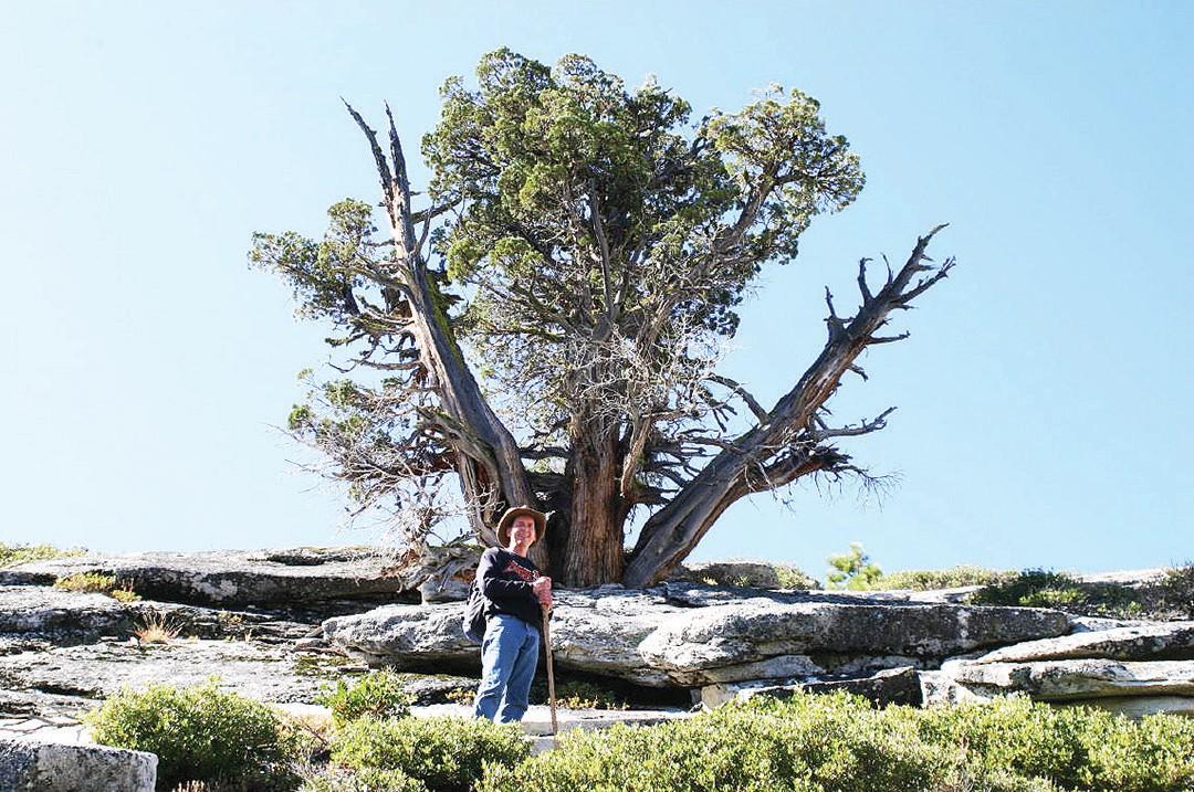

The author is shown standing in front of the big “W” leading to the summit.
During the past few months I have been asked by a few hikers if I would put into print the article on my adventure hiking to the top of Liberty Cap in Yosemite.
Here is that exciting adventure that I personally skipped by many times hurrying to another destination. I have been guilty of this practice for many years and with this article I will introduce you to one of my neglected adventures.
While hiking the Mist Trail in Yosemite toward Vernal and Nevada falls, standing proudly on the left is this steep mountain called Liberty Cap. At first glance, my thoughts were that this steep granite wall is a Class 4 climb which is above my skill level.
So, naturally, Liberty Cap was ignored for many years.
A few years ago I was doing research on John Muir and in his book the author wrote about Muir’s day hike to the top of Liberty Cap.
The author also made a point about how Muir departed from Glacier Point followed down the Panorama Trail, climbed Half Dome and Liberty Cap — all in one day.

Tony Krizan
But what caught my interest was the cross-country Class 2 route he took to the summit of Liberty Cap.
On a clear morning, Fred Cochran and I departed Oakhurst at 5 a.m. for Yosemite Valley. We arrived at Happy Isle around 6:30 and started our hike toward the Mist Trail following the Merced River.
Next we encountered those hundreds of stone steps on the Mist Trail climbing to the top of Vernal Fall. Did you know that in the 1860s they used wooden ladders in two stages to complete this 315 feet of elevation gain.
In 1869-70, Albert Snow completed the horse trail from the valley to the flat area between Vernal and Nevada falls. At this location, Snow and his wife, Emily, built a chalet or hotel called “LaCasa Nevada” in 1870.
The chalet opened on April 28, 1870, and was operational until the 1890s when it was destroyed by fire. All that remains today is the large vacant flat area located on the right of the trail.

Shown is the area above Vernal Fall.
Looking closely, you may find a few pieces of broken pottery scattered around the area. In the 1870s, John Conway extended the trail to Little Yosemite Valley and 15 years later a horse trail was completed to Glacier Point.
Above Nevada Fall is the junction of the John Muir Trail which we’ll follow into Little Yosemite Valley.
After passing through this forested valley, there are optional hiking destinations, such as the cables leading up to the summit of Half Dome. Or on a cloudy day, keep following the signs along the trail as it continues in elevation to Clouds Rest at 9,920 feet.
As the book stated, when Muir first entered the valley he departed from the trail and started climbing to the left through the rocks to a flat shelf. Once on the shelf, off in the distance to the west are Liberty Cap and a natural slot leading upward past two old snags.
Looking up at the top of this slot are two Jeffery pine trees that form a natural Letter “W,” and just past them is the end of this Class 2 route to the summit.

This is the bridge above Nevada Fall.
Liberty Cap, at 7,076 feet, had a series of name changes during those early years of Yosemite National Park. It was called “Cap of Liberty” or “Mount Broderick.” Those were also on the King and Gardner’s map of 1865 and the same identification title on Wheeler Survey sheet of 1876-79.
Also, the name carried Solomon’s map of 1896 read the same.
But on McClure’s map in 1896, it had “Liberty Cap” and the name was recognized as such ever since. From the top of Liberty Cap we enjoyed views of the granite wall of the south face of Half Dome at 8,842 feet and Glacier Point off in the distance at 7,214 feet.
Directly east is Mount Star King at 9,092 feet and Mount Clark at 11,522 feet. Slightly below in elevation is Mount Broderick at 6,706 feet. Excellent 360 degree views from this location.
On our return we attempted another direct cross-country route.
After dropping down through the slot we hiked across the high ridge until another natural slot led us down to Little Yosemite Valley and the John Muir Trail.

Shown is Little Yosemite Valley from the summit.
This hike took around six hours to complete using the suggestions of Muir’s book.
Tony Krizan describes himself as an “adventurer” and he explores the Sierra Nevada range on a regular basis. He can be reached at tonykrizan@hotmail.com.

Shown is the back side of Liberty Cap.

Tony Krizan is shown standing on the summit with Little Yosemite Valley in the backgrounds.

Shown are Nevada Fall and Liberty Cap.

This is on the trail just below Nevada Fall.



Responses (0)